Lougher to Swansea Bay and Return

From a few days of downpours, today was a contrast, cold but bright. A cycle ride was in order to blow the cobwebs away. I decided to start at Lougher Bridge and cycle to Swansea Bay utilising NCN 4 which is mainly traffic free.

Route

DSC00192

Tide in on the Lougher estuary

DSC00197

Tide out

The route leads from Lougher to Gowerton and then down the Clyne Valley and then onto Swansea Bay.

I turned right and headed out to Limeslade Bay for a coffee cycling through Mumbles and passing Verdis cafe and onto Fortes cafe.

DSC00193

Limeslade Bay

DSC00194

Bracelet Bay

DSC00195

Swansea Bay

DSC00196

Swansea Bay

The way back was just a reversal of the route.

There was room for a quick grumble in that the Swansea Bay trail is a shared path but with clearly distinguished  separation for walkers and cyclists. It’s a pity those walking  ignore this separation!!.


Swansea Bay

I had planned to watch my grandson play rugby in Waunarlwydd and to make the most of the day I decided to have a cycle ride after the game.

It was a good start as his team, Bynea under nines, came out on top. I then drove to Gowerton and cycled down route NCN4 down through the Clyne valley to Swansea Bay.

swansea-bay-005

From there I turned left and rode up and through the marina and returned back to Gowerton.

swansea-bay-001

swansea-bay-003

swansea-bay-004

There were lots of people cycling, walking and running despite an overcast day.


Llanmadoc

Despite being  in the throes of man flu, cabin fever kicking in and a blue sky day,  I struggled from my sick bed and headed out with Paul to walk part of the north coast of the Gower at Llanmadoc.

Route

The walk was taken from the Cicerone guide “Walking in Gower” and being reasonably short and flat I thought this would help my recovery. At the car park we chatted to a local who recommended the Cwm Ivy cafe situated just down the road and we filed this away for the return.

llanmadoc-001

We walked under Cwm Ivy Tor and onto the beach which we followed around to Whiteford Point. A detour was made to look at the Whiteford Lighthouse, the only surviving inter tidal cast iron lighthouse in the UK.

llanmadoc-004

llanmadoc-003

Our return route was adjacent to the salt marsh on one side and woodland on the other. The described route takes you along the sea wall but following a breach the path can no longer be used to get back to Llanmadoc. However the alternative is nice enough where we passed a renovated bunk house and then we were soon sitting in the Cwm Ivy Cafe where we pleased to find there was complimentary mulled wine and mince pies – result!

llanmadoc-006

A good end to a walk

llanmadoc-007

View from cafe

Gower Coast and Inland

With Mr and Mrs Navigator eking out their devalued euros it was left to to me to decide on a walk.

I found a walk described in a recent publication which seemed to fit the bill and would take in part of the south western coast of the Gower as well as some inland walking.

The forecast after some sunny days was for grey skies but dry. However there were grey skies but also  rain throughout the day! No doubt Chris, Paul and Daisy  would have been happier sitting around a nice warm fire with their feet up.

Route

There are few photographs as the views were mainly non existent.

We parked at Pilton Green and tokk a windy route to the coast path – there were a number of white way marking signs which we assume were there to avoid walkers tramping over crops. Unfortunately some were missing! We did manage to arrive on the coast but the mist and clag was low down and there was not much to see. Chris did point out a number of sea cliffs he had climbed in his youth.

gower 1

gower 3

The guide suggested keeping the coast and on to the Lookout Station which would have had views to Worms Head but by then with the continuous rain we were only interested in shelter to have our lunch. A decision was made to cut out the corner and head directly for Rhossili village where a convenient bus shelter was our chosen restaurant.

Following lunch we walked on to Middleton and then across country. We came across some limestone where a number of small cave entrances were seen – a past hobby of Paul.

gower 4

On our way we walked past a rustic furniture makker who had some wares on view. One of these was a comfortable looking seat which we were encouraged to try. Apparently the design was by a King of Malawi who had these made so that he could have carnal knowledge of his ladies in a position that was comfortable for him! INn the absence of any ladies we had to take the owners word for this.

gower 2

Back at the car it was still raining but as someone once said “a bad day in the hills is better than a good day in the office”.

Gowerton to Bracelet Bay and back

I had arranged to see my grandson play tag rugby at Gowerton Rugby Club on Sunday (he scored a try) and decided to take the bike along and have a ride down to Swansea Bay after.

Route

The route follows NCN 4 and is traffic free. With the fine weather the route along the Bay to Verdis Cafe was busy with walkers, runners and cyclists.

I extended the ride a little by cycling on to Bracelet Bay before returning to Gowerton.

it was good to be out as the weather has been bike unfriendly for some time.


Landimore Marsh North Gower

In the absence of The Navigator, Paul and I followed a route, number 26 from the Cicerone Guide “Walking on Gower”.

This was all new to me although I have cycled in the vicinity.

Route.

We parked at the end of a lane in Landimore on the salt marsh and headed west under the woodland on Tor Gro. This area was used as a firing range in the Second World War, but is now a peaceful place to be.

101_1337

101_1338

Where the track meets Burry Pill we stopped for a coffee and looked to our left to see the striking North Hill Tor which is the location of an odd named earth work, Nottle Hill Tor.

101_1339

This area can be flooded in high spring tides but there is a signpost for a high tide route.

101_1340

101_1343

101_1344

Today we were walking on a low tide and took the normal path up to Cheriton. At the bottom of the valley opposite a lovely old church we took the path signposted to Stembridge which crossed a number of fields with Burry Pill to our right.

101_1345

There was an old pack horse bridge to see which dates from at least 1500.

101_1346

101_1348

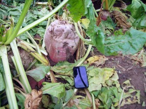
At the paths end we joined a road for a short while before turning left onto another path which led us past Samson’s Jack a large standing stone. We also came across a field with huge turnips.

101_1349

101_1350

Samson’s Jack is the  Gower’s largest standing stone  at 3.2 metres. Variously known as Mansell’s Jack or Sam(p)son’s Jack,  and legend holds that the stone holds such power as to equip its visitors with an answer to their most pressing question. When was lunch? The answer was not long and we found a comfortable place close to Weobley Castle.

101_1351

Refreshed we walked down to the coast path and headed back to the car.